Eastern Cape Potential
Crop Area Determination
The government of South Africa has initiated the Integrated Food and Nutrition Security initiative
(IFNSI) for South Africa which intends to assist the food insecure households and communities to
increase production of maize, beans, potatoes, vegetables and to some extend small livestock.
The latter will be achieved through provision of production inputs, facilitating provision of storage,
processing, and distribution.
- To put communal lands of the 23 Priority Districts into grains production, starting with the
Eastern Cape Province.
- To expand grains production to other land reform properties and communal lands in the former
Transkei area.
- To conduct an aerial crop survey starting in the Eastern Cape Province, this will assist government
to appreciate the grain production activities in the provinces.
- To identify the land, its capability, suitability, and current use patterns so as to commit resources
from an informed position starting with the Eastern Cape.
- To roll out the Eastern Cape model with modifications where necessary, to other provinces as
a medium to long-term sector plan to the food security needs of the country.
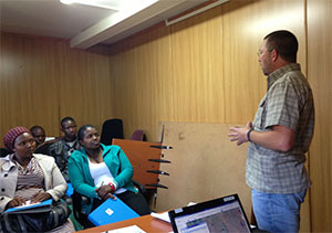
The project was initiated at a meeting that was held in the Eastern Cape with the Deputy Director
General from Department Rural Development and Land Reform in June 2013. The aim of the project
was to find the most suitable areas in the Eastern Cape for the expansion of crop production
in support of the Integrated Food and Nutrition Security initiative (IFNSI).
The project can be broken down into the following main activities:
- Mapping of field crop boundaries and agri-infrastructure
- Data Sourcing and Integration
- Aerial Observations
- Spatial Analysis and Modeling
Mapping of Field Crop Boundaries and Agri-Infrastructure:
To ensure that the field boundary mapping was done effectively the area of interest for the province
had to be identified, as not all of the Eastern Cape Province is suitable for crop production.
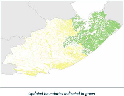
The North Eastern section of the Eastern Cape Province was derived as the area of interest by
utilising all available datasets like crop suitability maps etc.
The field boundaries were updated from Spot 5 images of 2011 and 2012 and a total of 809 383.6
ha were updated, which represents approximately 60% of all field boundaries in the Eastern
Cape.
The natural and planted forestry areas, developed areas, as well as erosion areas were also
mapped in detail as exclusion areas.
The crop field boundaries were mapped in more detail for all the government projects and irrigation
schemes and the name of the irrigation scheme or project (and project type) was captured
as well.
Agricultural infrastructure that could be identified from aerial photography or satellite imagery
was also captured during the digitising process.
Data Sourcing and Integration:
SiQ was responsible for the sourcing of existing data and Business Plans relevant to the project
and also for integrating the data into our current system and processes. The existing Crop Suitability
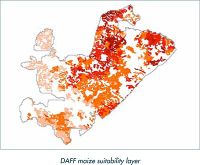
maps were immediately identified as one of the critical datasets for this project. After doing
some comparisons between the layers of the different sources, it was decided to use the DAFF
maize suitability layer that was compiled in March 2013 as the base layer in the model. This layer
shows the boundaries of areas that are suitable for maize production, with an indication of the
suitability class (very high suitability, high suitability, suitable, marginal suitability, low suitability).
Existing data was sourced from the Municipalities, Development Agencies, Cooperatives and
producer organisations such as Grain SA. Unfortunately these organisations had very little information
that has some form of spatial reference. As our approach and methodology are primarily
based on spatial information it made it difficult to optimally make use of their data. The typically
data was in the form of a Business Plan and the best spatial resolution that we managed to obtain
was Village Level (AA) data.
Aerial Observations:
Although the maize suitability layer provided a scientific base for the model, it was also necessary
to gather information on what was actually happening on the ground. This information was gathered
through an aerial observation survey.
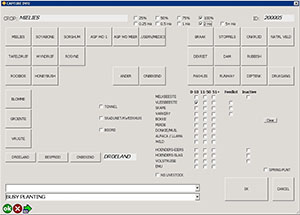
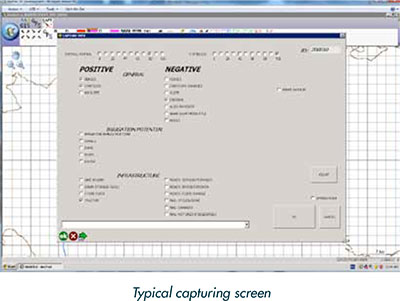
A grid of 2 km x 2 km was created for the whole area of interest and the aerial observation team
flew over each grid block to record the necessary information. The team consisted of one pilot
and two observers and information was captured through the use of tablet computers and Arc-
Pad software inked to a GPS and with a moving map indicating all the different map features. The
two observers captured different sets of information for each grid block namely:
- Information on crops planted, livestock and agricultural infrastructure present in the grid block
- Information on positive and negative factors that influence the suitability of the grid block for
maize production
A number of digital photographs that were all geo-referenced were also captured. These photos
could later be used for further verification.
Spatial Analysis and Modelling:
With regards to the ultimate spatial analysis of the data it became apparent that a modeling
approach had to be followed to incorporate all the layers of information derived from the field
surveys as well as the crop suitability maps.
A model was created that included all the information from the crop suitability index, datasets
indicating slopes, wetlands, gullies, forestry, villages as well other as the large number of parameters
of field data collected during the aerial observations. This model was developed in cooperation
with representatives from DAFF, Eastern Cape Department of Agrarian Reform, ARC and
some of its partners.
The model was largely based on the DAFF maize suitability layer, which provided the base value
for the model. For each additional factor that was applicable, the corresponding value for that
factor was added to the base score. No value was subtracted for negative factors, but provision
was made for exclusions. Slopes steeper than 8%, erosion areas (excluding sheet erosion), wetlands,
forestry and villages / development were excluded from the model.
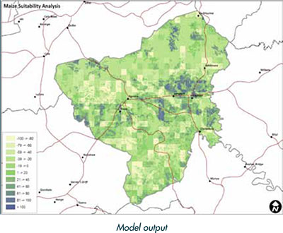
The map below is an example of the output from the model that was run on the Engcobo area.
The result was a layer that has a final score for each polygon, except for exclusion areas. In essence
the map below is indicating areas that are less suitable for crop production in lighter green
whereas the darker blue areas on the map are more suitable for crop production.
|