|
|||
Occupancy SurveysSiQ conducts occupancy surveys in low income areas to:
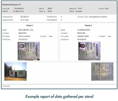
These surveys are done for clients such as the Department of Human Settlements and the housing departments of various municipalities or metros. In some instances SiQ is not directly appointed but is subcontracted by consulting engineering firms such as the SCIP Engineering Group (a major player in the planning and supervision of housing provision). Typical information that must be captured per household of every stand are:
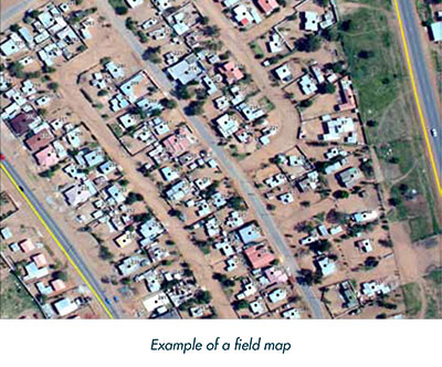
This information is captured together with the actual spatial location of the captured data (i.e. a GPS point). Before starting with any area it is very important to arrange an information session with the councillors/chiefs/heads of the area explaining the purpose of the survey and asking for their assistance in communicating the purpose of the project to the community. It is essential to obtain the cooperation of the community to ensure the success of the project. Helpers from the community are also appointed to assist the surveyors in obtaining access to the properties and making the community members feel more at ease. In order to get complete coverage of an area, and to ensure that no households are missed, the only sure way of approaching such a survey is spatially. The next step thus is to compile field maps that are being used in the field by the surveyors. Aerial photography is utilised as backdrop and points are placed in the office on every group of structures on a stand and a unique number allocated to each point. The purpose of the field maps are:
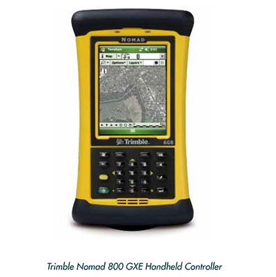
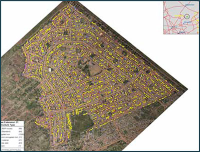
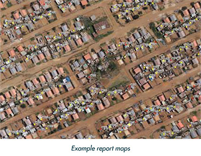
The cadastral boundaries, aerial photography and the points that must be surveyed are displayed on the field maps. Various devices are used in the field based on the requirement of the survey, e.g. is it necessary to take a photograph or must the barcode in the ID book be scanned. Mostly use is made of the Trimble Nomad 800 GXE handheld controller to capture the data because of the endless functionalities. The operating system is Windows Mobile 6 with 6 GB memory. The device has a built in GPS, modem, laser scanner and camera to make data capturing very easy. It also has the ability to display aerial photos on the screen while one is capturing data and therefore one can already do first level quality control in the field. Trimble TerraSync or ESRI Arcpad Software is being used on the handheld capturing device. It is possible to set up a data dictionary beforehand for the parameters that must be captured. This makes the capturing much easier for the surveyor and ensures that there are no inconsistencies in the data that is received from the field. Quality assurance can also be built into the capturing software. Before the surveyors start in the field, a first phase of training is given in the office to explain all the steps that must be followed as well as the use of the hardware and software. A second phase of training is given in the field to ensure that the surveyors know exactly how to conduct an interview. The field manager accompanies the fieldworkers on the first couple of days to ensure that they know exactly what to do. Where helpers are employed training is also given to them in the field. Typically a specific stand is visited a maximum of three times, of which one of the visits should be done over a weekend, if the occupant cannot be interviewed. The data captured from the field is downloaded or synchronized on a regular basis and reviewed. Feedback is given immediately of general mistakes made in the field. It is extremely important to do regular quality assurance and give feedback, especially in the beginning of the project to avoid the same mistakes being made on a large number of survey points. SiQ is always focused on maximizing efficiency and accuracy and are committed to provide deliverables to our clients that are of the highest standard. To achieve these objectives, SiQ developed a well-documented process for the efficient capture of accurate data, as well as quality assurance. A final quality assurance check of the data is done in the office after the whole area has been surveyed and checked. These quality assurance checks are done on an attribute as well as on a spatial level. All the data collected in the field is linked to the cadastral data and a report compiled for the client that consists of maps with cadastral boundaries and aerial photography, as well as the data gathered per stand with the ID and house photos taken. SiQ's structured approach to the project, as well as processes that have been put in place regarding training, data capturing, quality assurance and tracking of progress, ensures that high quality data is delivered to the client in a timely fashion. |
|