The Woody Alien Invasive
Monitoring System Project
Woody alien invader species has become a huge problem in South Africa. Probably one of the
biggest concerns is the fact that it is not known what the total number of hectares of land that
have been invested by these species. One of the challenges has been a cost effective way of
mapping and determining the areas that have been invested. SiQ developed a cost effective solution
to map and survey large areas. This methodology has been implemented very successfully in
the crop estimates field and we were convinced that this would be a potential solution for establishing
the area under woody alien invader plants.
The Institute for Soil, Climate and Water (ISCW) of the Agricultural Research Council (ARC) appointed
SiQ as subcontractor for the Woody Alien Invasive Monitoring System project (WAIMS).
The ARC was appointed by the Department of Water Affairs and Forestry through their ‘Working
for Water’ programme to determine the geographical distribution and estimated area of woody
alien invasive species in the whole of South Africa, Lesotho and Swaziland. The project was
launched in August 2007 and completed in August 2008.
The ARC utilized modeling techniques and remote sensing to establish potential maps with the
likelihood of finding woody alien invader species. A sampling approach was followed where the
areas with a high likelihood of finding these species were sampled more densely than the areas
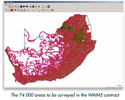
where the likelihood was low of finding these species. The result was a map covering the whole
study area comprising of 74 000 areas to be surveyed (1 hectare areas).
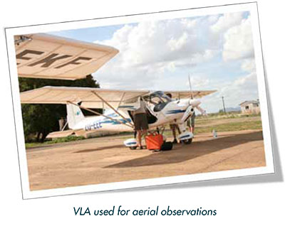
SiQ used very light aircraft and helicopters to conduct an aerial observation survey of all the areas.
Observers experienced in identifying alien invasive plants were utilized to do the data capturing
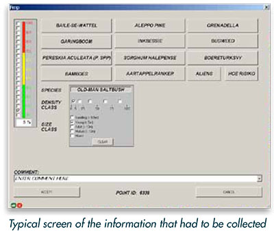
from the aircraft. The three dominant woody alien invader species of each area had to be identified
including each individual size class and density class.
A digital photo was taken of each area and automatically linked to the area to verify the data.
After the aerial data capturing, points were selected for ground verification to confirm the accuracy
of the data captured from the air.
Software (GiS based) was customized to be able to capture all the required data. A combination
of technology and experience made it possible to capture high quality data.
The survey was completed successfully and the data delivered to the client within the 12 month
timeframe.
|